


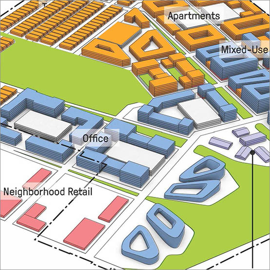
The Woodbine Racetrack site envisions a new future: A City within a City – an exhilarating place to live, work, study and recreate.
The project transforms the largest undeveloped tract within Toronto into an iconic and dynamic, fully integrated, transit-oriented mixed-use district. Capitalizing on the racetrack’s legacy and the site’s natural, cultural, and locational assets, the project is designed to become a new heart in Toronto.
The master plan includes a diversity of open spaces throughout to provide relief and respite. These spaces are anchored by the green corridor, connecting the Humber River Valley to Mimico Creek, the racing surfaces and infield, Woodbine’s Central Park, and the Urban Promenades that structure the built environment. Anchoring the western portion of the site is the green corridor. Due to the drainage basin divide that occurs in the NW corner of the site, the green corridor is divided into two portions. The northern portion drains to the Humber River and the southern portion drains to Mimico Creek with the divide being New Providence St. The water in the green corridor is set up as a series of ponds, to traverse the topography and to ensure a high aesthetic quality of the water. The northern ponds have the potential to be part of a staged quality control facility before outletting to the Humber River. The other ponds can be incorporated into the storm water management system as aesthetic ponds.
Related Projects
Nasu Highland
SWA collaborated with the architect to provide site planning, schematic landscape design and design development for this brand new membership clubhouse facility with an 18-hole golf course designed by Robert Trent Jones, Jr., International. The development includes a major arrival entry with a stone podium surrounded by a fountain pool. The clubhouse is surrou...
Disney World Master Plan
Special issues in the computer-aided land analysis included depth to watertable, soils and organic mucks, and cypress groves. The analysis summary provided the basis for master planning a mixed-use community with extensive greenway conservation lands, resort development, entertainment facilities, a business park, and a residential community.
2010 Asian Games Village
SWA collaborated with the Guangzhou Urban Planning Design & Survey Institute on a new urban design concept for the 2010 Guangzhou Asian Games. Situated between mountains to the North and the Pearl River to the South, Guangzhou has a unique condition, which allows for the use of existing water channels for the framework of a new open space network. By abstr...
Amber Bay
The Amber Bay residential development is located on a beautiful rocky promontory that is among the last available parcels along the Dalian shoreline, southeast of the city center. The project features high-end low density modern style residential development including single family villas, townhouses, and low-rise condominiums; shops and seafood restaurants on...
Bayou Greenways
As one of the largest U.S. cities, Houston’s sprawling, car-centric infrastructure is underpinned by a vast arterial system of over 2,500 miles of bayous—an untapped ecological feature that could redefine urban life.
Recognizing this potential, the Houston Parks Board worked alongside SWA to develop a visionary plan for nine central bayous as an i...
Woodbury
SWA provided planning services related to entitlement and land use for 1,400 acres of land in the City of Irvine, representing the last “flat land” development within the Irvine Ranch. Fundamental to the planning of Woodbury was the concept of a village “commons” with a mix of retail, residential, and office uses, which also includes a recreation c...
Nanjing International Youth Cultural Centre
SWA was retained to design the landscape of this mixed-use development collaboratively with Zaha Hadid Architects. It contains performing arts, hotel, residential, office and retail functions. Located adjacent to SWA’s Nanjing Youth Olympic Park, the design strives to merge architecture, the park landscape, and people at this iconic focal point. Landform...