Growing, densifying cities have no room to waste in their search for public open spaces. They are converting derelict railroad corridors and abandoned freeways into leafy, pedestrian-friendly pathways and rejuvenating existing green spaces and waterfronts to serve recreational functions and bring city dwellers close to nature.
The following ten projects in the Asia Pacific region—all completed during the past five years—include restored headlands, contaminated canals and marshes cleaned up to serve as wildlife habitats, a row of parking spaces revamped as a piazza, and a rail line and a highway turned into linear parks.
1. Barangaroo Reserve
Sydney, New South Wales, Australia
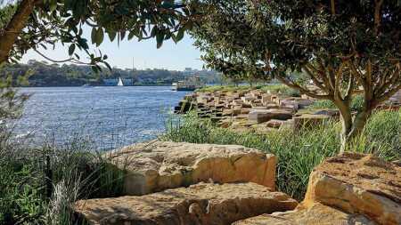
Long a hunting and fishing ground for the Aboriginal Cadigal people, Sydney Harbour’s foreshore began to be filled in for maritime uses in the mid-19th century. In 2003, the New South Wales government decided to turn a 22-hectare (54 ac) container port at the edge of the city’s central business district into a new mixed-use district called Barangaroo, after an Aboriginal woman who was influential in colonial Sydney. The first precinct, opened in 2015, is Barangaroo Reserve, a re-created six-hectare (15 ac) headland that replaces the container port’s concrete with large lawns, pathways, an Australian bush garden, and an amphitheater.
Ten thousand blocks of Sydney’s distinctive sandstone excavated at the site line the water’s edge, allowing the public to explore beaches and tidal pools. Pedestrian and bicycle paths flank a low sandstone wall marking the precolonial shoreline. Nearly all the plants are native to Sydney. PWP Landscape Architecture, based in Berkeley, California, designed the reserve with its Sydney partner, Johnson Pilton Walker Architects. The Sydney office of WMK designed the Cutaway, a large underground multiuse cultural space, as part of the project.
2. Esperance Waterfront
Esperance, Western Australia, Australia
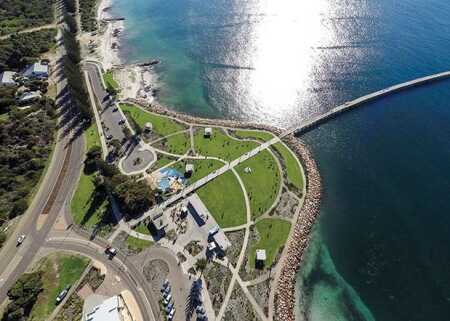
With Western Australia’s population expected to more than double by 2050, the government selected nine towns to assist with planning to accommodate that growth. As part of these plans, the Shire of Esperance chose to redevelop its waterfront as a family-oriented destination by improving infrastructure and adding tourist attractions. The Perth office of design firm Hassell reclaimed the headland, adding a large lawn for community gatherings and recreation, plus space for pop-up events and food trucks.
A new plaza links the waterfront to the town. Interpretive signs and public art convey stories of local history. Landscaped paths, playgrounds, seating areas, picnic shelters, and barbecue stations offer amenities for locals and tourists. Extensive planting of native trees and shrubs has helped reduce erosion in tandem with a new seawall that follows the natural contours of the headlands. Local materials such as pink granite and reclaimed timber from the historic jetty were incorporated into the project, completed in 2015.
3. The Goods Line
Sydney, New South Wales, Australia
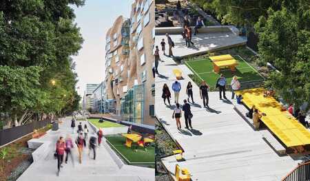
From the 1850s until 1984, freight trains carried commodities like wheat and wool from Darling Harbour. After the rail line closed, the corridor lay fallow in one of the most densely populated areas of Sydney, flanked by the University of Technology Sydney and vocational education provider TAFE NSW. Now the state government has transformed a portion of the corridor into the Goods Line, a linear park with amenities for the community. A wide pedestrian and bicycle pathway constructed of precast concrete planks floats over the original rails, some of which remain exposed as a reminder of the corridor’s original use.
Off the main path, platforms hold raised lawns, bleachers, terraced seating, communal tables equipped with power sources and wi-fi, an amphitheater, a children’s play area, table-tennis tables, and spaces for pop-up events and festivals. Materials such as gravel, steel, and timber reference the site’s history. Designed by local firms Aspect Studios with CHROFI for Property NSW, the New South Wales property agency, the 275-meter-long (900 foot) first phase opened in 2015.
4. Kranji Marshes
Singapore
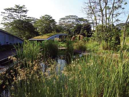
When Singapore dammed the Kranji River to create a reservoir in the 1970s, the area flooded and became a freshwater marshland, an important feeding and nesting area for birds and other wildlife. Over the decades, however, sediment buildup and invasive plant species shrank the amount of open water and reduced wildlife and plant diversity. Singapore’s Urban Redevelopment Authority and National Parks Board brought in local firm Stephen Caffyn Landscape Design to restore the marshland and create limited public access.
Dredging increased the open water area from 0.5 to 8 hectares (1.2 to 20 acres). The project also involved replacing invasive plants with native species, reshaping land areas to maximize habitat, and adding visitor facilities. Structures such as an outdoor classroom and a viewing tower were prefabricated off site to minimize construction impact. Floating boardwalks allow visitors to walk near the marsh. Interpretive signs throughout give information about the site’s ecology and the restoration project. New trails wind through the grass, woodland, and marsh habitats, with a core conservation area open only to those taking guided tours. Kranji Marshes opened in 2016.
5. Mary Street Piazza
Vincent, Western Australia, Australia
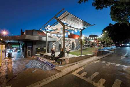
The intersection of the city of Vincent’s main thoroughfare, Beaufort Street, with Mary Street was a sore spot for pedestrians, with traffic congestion resulting from drop-offs at the nearby school and rapid-turnover street parking. The Beaufort Street Network, a collective of area business owners, residents, and landowners, brainstormed solutions and suggested narrowing Mary Street and repurposing nine street parking spaces to create a public piazza. The municipality adopted the idea and brought in the Perth studio of Place Laboratory to carry out the community’s vision for a space that could serve a variety of uses.
Combining lawn and paved areas, new trees, a shade structure, picnic tables and movable stools, bicycle parking, artwork, and a performance stage, the piazza hosts everything from pop-up yoga to children’s film nights. The bakery and restaurant fronting the piazza offer outdoor seating, capitalizing on the space’s energy. Lighting keeps the area active at night even when the stage is quiet. As part of the project, Mary Street was reconfigured as a one-way street, streamlining the school drop-off process. The piazza opened in 2015.
6. Nanchang Greenland Jiangxi Gaoxin
Nanchang, Jiangxi Province, China
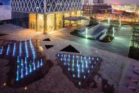
In Nanchang’s high-tech district of Gaoxin, Shanghai-based developer Greenland Group constructed a 56-story office/hotel tower designed by the Shanghai office of SOM. A grid of triangular aluminum fins shields the glass exterior from solar heat gain and gives the building a distinctive look on the skyline. In designing the four-hectare (10 acre) plaza at the foot of the tower, the Shanghai office of SWA Group picked up on the tower’s geometry: the patterning of tree placement, planter beds, benches, and paving all draw on triangular forms.
Trees line the perimeter, shading the open space and sheltering it from the street. Triangular stone seating provides places for casual meetings, relaxing, and viewing LED displays projected onto the building’s facade. At night, LED lighting in the paving adds sparkle to the area and illuminates sprays from the plaza’s interactive fountain. The building’s podium contains ground-floor shops and is topped by terraces with café and restaurant outdoor dining areas, stone paving, triangular grass berms, and gravel. The project was completed in 2015.
7. Nanjing Hexi Urban Eco Park
Nanjing, Jiangsu Province, China
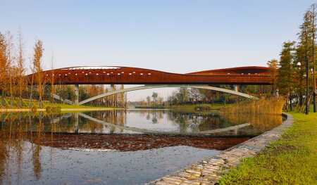
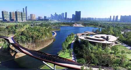
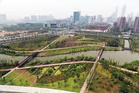
In preparation for the 2014 Youth Olympic Games in Nanjing, the municipality decided to construct Hexi New City, a commercial and financial city center to the south of Nanjing’s historic core at the confluence of the Yangtze, Jiajiang, and Qinhuai rivers. Opened in 2016, Hexi Urban Eco Park provides open space for the new city center, reachable by subway, electric tram, and water transit, as well as by car. In designing the park, the Shanghai office of AECOM created a channel across the site that links the park’s lake with the city’s water network, collecting stormwater to mitigate flooding during the rainy season.
The sculptural pedestrian bridge crossing the channel provides framed views of the park through openings punched into its walls. Partially shaded lawns, meandering paths with benches, a boardwalk, a boat quay, and a large plaza at the water’s edge provide various ways for visitors to engage with the lake. On hot summer days, a fountain creates mist and gives children a cool place to splash about. A pavilion features information on leading a zero-carbon lifestyle.
8. Ningbo East New Town Eco-Corridor
Ningbo, Zhejiang Province, China
To accommodate population growth, the port city of Ningbo’s planning bureau called for the creation of a new mixed-use district, East New Town. The site had a network of historic canals that once served as a means of flood control, irrigation, and transportation, but by the end of the 20th century, industrial use had left them contaminated and disconnected. The bureau brought in SWA Group to replace the canals with a new, meandering watercourse linked to free-flowing streams, ponds, and marshland.
Excess dirt from nearby new developments was repurposed to shape hills and valleys that facilitate stormwater management. Replacing concrete canal banks with vegetated slopes created wildlife habitat and, in tandem with bioswales and rain gardens, helps filter stormwater runoff. To reconnect the public with the natural world with minimal disturbance to sensitive areas, a trail system leads to elevated boardwalks, bridges, and bird blinds. Completed in 2014, the three-kilometre-long (2 mi) linear park functions as the spine for the new town’s open spaces and has increased the presence of wildlife in the area.
9. Quzhou Luming Park
Quzhou City, Zhejiang Province, China
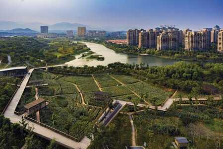
To offer recreational opportunities to a high-density new development, the government of Quzhou City chose a 32-hectare (80 ac) site along the Shiliang River for transformation into an urban park. The existing site was a hodgepodge of bushes, grasses, parts of abandoned agricultural fields, rolling hills with exposed red sandstone, a riparian floodplain, and a linear tree grove. Rather than level the site and insert a park, a common strategy in the region, Beijing-based landscape design firm Turenscape left the patchwork in place, preserving relics of the past—such as existing village trails and an old pump house—as part of the area’s cultural heritage.
Turenscape kept the existing drainage system, too, enhancing it with additional bioswales to capture and filter stormwater. Removing concrete embankments returned the river and wetlands to a natural state. The empty fields were replanted with productive crops, which are rotated seasonally. Lawns provide space for camping, athletics, and play. New infrastructure includes bridges, boardwalks, pavilions, platforms, and a viewing tower. The park opened in 2017.
10. Seoullo 7017 Skygarden
Seoul, South Korea
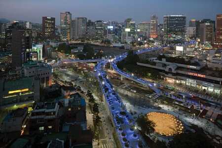
In the 1960s and 1970s, Seoul erected dozens of elevated freeways to speed traffic through the dense city. In recent years, the city has been tearing down some of this aging infrastructure for safety reasons. This was originally the plan for a 1970s overpass that crossed over the Seoul Station railway hub. Instead, as part of efforts to make the city more pedestrian friendly, officials decided to strengthen the concrete-and-steel structure and repurpose it as a 983-meter (3,200 ft) linear park.
The park includes hundreds of pots containing 24,000 plants—trees, shrubs, and flowers. The goal is to use the park as a nursery, moving trees, as they mature, to city streets and replacing them with new pots. Stairs, elevators, and escalators connect Seoullo 7017 to the ground level at multiple points, and bridges link it directly to buildings. Blue LEDs illuminate the park at night. Completed in 2017, Seoullo 7017 was designed by MVRDV, based in Rotterdam, with Delft-based landscape architect Bureau Ben Kuipers and local architecture firm dmp.

